SEAFDEC/AQDINSTITUTIONAL REPOSITORY
    • Login
    View Item 
    •   SEAFDEC/AQD Institutional Repository Home
    • 03 SEAFDEC/AQD External Publications
    • Journal Articles, Conference Papers and Book Chapters by SEAFDEC Staff
    • Journal Articles
    • View Item
    •   SEAFDEC/AQD Institutional Repository Home
    • 03 SEAFDEC/AQD External Publications
    • Journal Articles, Conference Papers and Book Chapters by SEAFDEC Staff
    • Journal Articles
    • View Item
    JavaScript is disabled for your browser. Some features of this site may not work without it.

    Practical techniques for mapping small patches of mangroves

    • Global styles
    • APA
    • Elsevier - Harvard
    • Vancouver
    • MLA
    • Help
    Thumbnail
    View/Open
    Request a copy
    Date
    2010
    Author
    Altamirano, Jon P. ORCID
    Primavera, Jurgenne H. ORCID
    Banaticla, Ma. Regina N.
    Kurokura, Hisashi
    Page views
    2,942
    Metadata
    Show full item record

    Cited times in Scopus


    Share 
     
    Abstract
    Practical mapping methods employing GPS field surveys and manual image analyses with affordable software were used to assess two mangrove sites in Aklan Province, NE Panay Island, central Philippines. The Jawili mangroves, absent from current maps, actually included 21.5 ha with 24 true mangrove species. On the other hand, the Batan Estuary mangroves, shown to be 4244 ha in available topographic maps, revealed only 406 ha of scattered patches. Actual mangrove data on specific areas worldwide is limited, especially in the Philippines where available maps show discrepancies from actual mangrove distribution. Remote sensing (RS) techniques provide promising results but require expensive setup, particularly for small areas. Therefore, financially limited users need affordable and rapid mapping alternatives. The practical techniques presented here can be immediately implemented at minimal cost and can produce useful estimates of actual mangrove area, fundamental for coastal management. Basic principles used here also have potential applications in other systems and locations. When resources are available though, additional confirmation and precise mapping are also further recommended.
    URI
    http://hdl.handle.net/10862/1005
    Suggested Citation
    Altamirano, J. P., Primavera, J. H., Banaticla, M. R. N., & Kurokura, H. (2010). Practical techniques for mapping small patches of mangroves. Wetlands Ecology and Management, 18(6), 707-715.
    DOI
    10.1007/s11273-010-9190-2
    Type
    Article
    ISSN
    0923-4861
    Subject
    Topographic maps; Estuaries; Remote sensing; Wetlands; Mapping; Manuals; Patchiness; Mangroves; Coastal zone management; Computer programs; Software; Data processing; Islands; Image processing; Remote sensing; Costs; Surveys; Maps; Mangrove swamps; Digitized map; GPS tracking; Mapping; Philippine mangroves; Rapid assessment; GIS; Aerial Photographs; Management; Ecosystems; Patterns; Ikonos; Coast; Philippines
    Collections
    • Journal Articles [1108]

    Related items

    Showing items related by title, author, creator and subject.

    • Thumbnail

      Application of GIS in shrimp disease surveillance and monitoring 

      Lavilla-Pitogo, Celia R.; Biñas, Joseph B. (National Mapping and Resource Information Authority, 2009)
    • Thumbnail

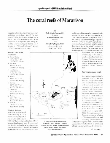
      The coral reefs of Mararison 

      Garcia, Luis Maria; Marte, Clarissa; Agbayani, Renato F. (Aquaculture Department, Southeast Asian Fisheries Development Center, 1998)
    • Thumbnail

      Survey and assessment of mariculture activities in Panabo Mariculture Park (Davao del Norte), Tagabuli Bay and Malalag Bay (Davao del Sur) 

      Southeast Asian Fisheries Development Center, Aquaculture Department; Taytay sa Kauswagan Inc.; Development Bank of the Philippines (DBP); Norwegian Agency for Development Cooperation (Aquaculture Department, Southeast Asian Fisheries Development Center, 2013-07)

    © SEAFDEC/AQD  2021
    Contact Us | Send Feedback


    Browse

    All of SAIRCommunities & CollectionsBy Issue DateAuthorsTitlesSubjectsKeywordsThis CollectionBy Issue DateAuthorsTitlesSubjectsKeywords

    My Account

    LoginRegister

    Statistics

    View Usage Statistics
    SEAFDEC/AQD Library

    © SEAFDEC/AQD  2021
    Contact Us | Send Feedback


    Export citations

    Export the current results of the search query as a citation list. Select one of the available citation styles, or add a new one using the "Citations format" option present in the "My account" section.

    The list of citations that can be exported is limited to items.

    Export citations

    Export the current item as a citation. Select one of the available citation styles, or add a new one using the "Citations format" option present in the "My account" section.

    Export Citations

    EXTERNAL LINKS DISCLAIMER

    This link is being provided as a convenience and for informational purposes only. SEAFDEC/AQD bears no responsibility for the accuracy, legality or content of the external site or for that of subsequent links. Contact the external site for answers to questions regarding its content.

    If you come across any external links that don't work, we would be grateful if you could report them to the repository administrators.

    Click DOWNLOAD to open/view the file. Request a copy in case the link we provided don't work.

    Download

    DOCUMENT REQUEST NOT AVAILABLE

    This publication is still available (in PRINT) and for sale at AQD bookstore. The library is currently restricted to send PDF of publications that are still for sale.

    You may contact bookstore@seafdec.org.ph or visit AQD bookstore for orders.

    FILE UNDER EMBARGO

    This file associated with this publication is currently under embargo. This will be available for download after the embargo date.