LakeCon2003: Recent submissions
41-49 / 49
-
Protein-degrading bacteria in the sediments of caged and uncaged sites of Lake Taal, Batangas, Philippines
(Southeast Asian Regional Center for Graduate Study and Research in Agriculture (SEARCA), 2005)The populations of protein-degrading bacteria in the sediments of caged (Leviste, Laurel) and uncaged sites (Quiling, Talisay) in Lake Taal were determined by means of the most probable number (MPN) enumeration using nutrient broth containing 12% gelatin. Protein degradation was checked through the liquefaction of gelatin. Results showed that protein degraders in the caged site had MPN of 1.53 x 10¹⁰/g dry weight of sediment while the uncaged site had MPN of 6.95 x 10⁹/g dry weight. The populations were 4.98% and 50.0% of the total aerobic heterotrophic bacteria in the sediment for the caged and uncaged sites, respectively. The results indicate that: (a) active protein-degrading bacteria exist in the lake which could readily degrade any proteinaceous feeds present; and (b) there is no big difference between the populations of protein-degrading bacteria in the caged and uncaged sites, the latter possibly being a caged area in the past. These protein-degrading bacteria were identified as probably Bacillus, Aeromonas and Burkholderia. Isolate B44, a Bacillus isolated from the caged site, was found to be the most rapid liquefier of gelatin (liquefaction in three hours). -
Assessment of migratory fishes in Butas River, Naujan, Oriental Mindoro, Philippines
(Southeast Asian Regional Center for Graduate Study and Research in Agriculture (SEARCA), 2005)To determine the declining production of migratory fishes (milkfish, mullet, snapper, jacks) in Naujan Lake, environmental assessment of Butas River is being conducted. Water quality is being monitored and fish samples were collected once a month from April to December 2003. Four stations were considered: Station 1 with Barangay Melgar A; Station 2, Barangay Concepcion; Station 3, Barangay Dao; and Station 4, Barangay Bayani. Water temperature, pH, transparency, dissolved oxygen, and water depth were determined in-situ. Gill net or pante was used in collecting fish samples. Results show that water parameters are not significantly different between stations except water depth. Stations 2 and 3 (mid portion of the river) are relatively low compared to Stations 1 and 4. Migratory fishes collected are mullet, milkfish, and caranx in Stations 1 and 4. Water depth in the mid portion of Butas River is decreasing as a result of heavy sediment disposition. Siltation could be attributed to erosion and other activities like farming and construction of road along Butas River. Migratory fishes in Naujan Lake are considered endangered due to overfishing, introduction of exotic species, and construction of fish corral. Dredging Butas River is recommended to descend migratory fishes from Naujan Lake to Mindoro/ Tablas Strait and ascend from sea to lake. Dredging the river will increase its productivity as it has been noted that no ecological disturbance would occur during dredging. There is also a need to strictly implement Fisheries Administrative Order 217 Series of 2001 Obstruction to Defined Migratory Paths by the Local Government to protect migratory fishes in Naujan Lake. -
Response of phytoplankton to temporal changes in nutrients in Taal Lake, Batangas, Philippines
(Southeast Asian Regional Center for Graduate Study and Research in Agriculture (SEARCA), 2005)It is important to note that different adaptations are successful at different times and in different environments, so that different algal species become dominant at different times and locations. Hence, the species composition of the phytoplankton community is arbitrary, but allows the alert observer to discover the characteristics of the lake or pond investigated, including nutrient status, climate acidity, and the composition of the grazer community. Phytoplankton taxa collected and identified within the sampling regime were subjected to ordination within the set of environmental axes and revealed that indeed, and the vectors in the absorbed data of Ceratium can be assumed largely for NH4-N, and soluble and total P. A positive correlation between Ceratium and NH4 is stronger than that of total P and soluble P. Vectors in the absorbed data for centric diatoms, Selenastrum, Phormidium, Coelastrum, Chroococcus, and Oscillatoria, can be assumed for largely by NO3. The location of the sampling stations, months and depths within the Canonical Correspondence Analysis (CCA) ordination field with the same environmental factors defining the axes were also analyzed. The least important environmental variable considered in this study was the soluble phosphate with the shortest vector among the other factors. The study also found out that the nutrient status of the lake appears to influence it during the dry season. It must be noted though that 2.5 m depth collections were considered in this data and may not be very reliable because of the nature of the flow of nutrient in a deep lake being dispersed in the deeper portion and remains drift to the bottom (Smith, 1996). Previous discussions on statistical analyses support these results from Multivariate Statistical Package (MVSP). Observations on the temporal changes in nutrients and the phytoplankton biomass and cell count are found parallel to the studies of Lewis (1978) in Lake Lanao, Martines (1977) and Zafaralla (1990) in Laguna de Bay. -
Nutrient and bacterial load profile of Lake Mainit, Mindanao, Philippines
(Southeast Asian Regional Center for Graduate Study and Research in Agriculture (SEARCA), 2005)Lake Mainit, located in northeastern Mindanao, is the fourth largest lake in the Philippines. Its limnology and water quality parameters, however, are not yet thoroughly understood. This study has been conducted to obtain the bathymetry, the vertical temperature-dissolved oxygen profile, and the vertical variations of nutrients in the lake basin including those coming from river tributaries. The bacterial load profile of certain areas has also been studied to determine the levels of coliform bacterial contamination in the lake water. The bathymetric profile of Lake Mainit indicates that the shallowest portions are in the north and south ends of the lake. These portions become progressively deeper towards the center at over 200 m. Maximum depth recorded is 218.75 m. Steep slope dropping off sharply towards the 200-m depth is found at the western coast of the lake along the Malimono Ridge while the eastern coast has a gently sloping profile. The vertical temperature profile of the lake ranges between 26.55°C - 30.00°C with the thermocline layer being observed between 10 m to 40 m. Variations in vertical temperature have been observed at 0 m down to a depth of 30 m. Beyond this depth, variations are minimal ranging between 0.03°C - 0.15°C. The dissolved oxygen concentration at the epilimnion ranges between 7.31 - 7.67 mgOL-1. Below the thermocline, it rapidly decreases to <2 mgOL--1 from 50 m down to the 200-m depth. The oxycline has been observed between 10 m - 40 m. The vertical nutrient profile shows a uniform NH3-N concentration from 0 m - 60 m which significantly increases at 80 m to 200 m. A decreasing trend in the NO3-N profile has been observed between 0 m to 30 m which then increases at 60 m to 200 m. Phosphate concentrations are relatively low at 0 m - 40 m. Nutrient measurements from 14 river tributaries show high concentration levels with sources coming from predominantly agricultural lands and residential areas. Bacteriological analyses of water samples coming from 12 sampling stations show high total and fecal coliform (350 to 1600 MPN/100 ml) in the three populated areas around the lake. The study indicates that Lake Mainit is an oligotrophic lake based on its physico-chemical and morphometric characteristics. However, natural productivity and optical properties of the lake waters should also be considered in determining its classification. -
Lake Taal's freshwater sardines Sardinella tawilis (Herre): Evolutionary insights based on morphological, molecular, and geological data
(Southeast Asian Regional Center for Graduate Study and Research in Agriculture (SEARCA), 2005)Sardines (family Clupeidae or herrings) are mostly marine species. In the Philippines, Lake Taal is the habitat of Sardinella tawilis (local name tawilis ), the only local endemic sardine species known to be fully adapted to a freshwater environment. Its evolutionary history is thus of great interest. So far, analyses of morphometric, meristic, isozyme, and mtDNA data point to the marine species Sardinella albella as the closest marine relative. Furthermore, mitochondrial DNA data revealed restricted substitution that may indicate either the beginning of a genetic differentiation of two tawilis sub-populations or the ghost of polymorphism past strengthened by genetic drift. Sardinella tawilis is believed to have emigrated from Balayan Bay to Lake Taal when it was formed in the course of volcanic eruptions some 240 years ago. The data do not, so far, support this contention. An alternative explanation on the speciation of this species is presented here. -
A limnological survey of Lake Duminagat, Mt. Malindang Natural Park, Misamis Occidental, Philippines
(Southeast Asian Regional Center for Graduate Study and Research in Agriculture (SEARCA), 2005)Lake Duminagat is a crater lake located in Mt. Malindang Natural Park, one of the protected areas in the Philippines. Two communities are adjacent to it - Brgy. Duminagat, of which it is a part, and Brgy. Gandawan. Both barangays are part of the municipality of Don Victoriano, province of Misamis Occidental. The municipality of Don Victoriano is entirely circumscribed by the Park which represents the flora and fauna of the Zamboanga biogeographic zone. This paper focuses on the objective of characterizing the limnology of Lake Duminagat - its morphology, its physico-chemical components and its biota. The area of study consists of valleys and mountains. Brgy. Gandawan, Brgy. Lake Duminagat, and the lake basin are considered as crater valleys, surrounded by variably tall mountains. Being at a high elevation (~1,240 to 1,560 masl), the climate in the Lake Duminagat area is cooler compared to the lowlands. The area belongs to the region classified as Intermediate B type with no very pronounced maximum rain period and no dry season. Annual rainfall is 2099 mm. Lake Duminagat is a small lake, with an area of 8.04 ha, maximum depth of 20.95 m, water volume of 933,000 m3, mean depth of 11.6 m, shoreline length of 1,060 m, and shoreline development of 1.054. It is a thermally stratified lake, though whether it undergoes periodic mixing was not determined. The water is low in alkalinity and is very soft. The water at the middle of the lake is potable enough for drinking at various times of measurement. Its various morphometric and physico-chemical characteristics such as a low surface area to volume ratio, low lake area to watershed area ratio, low alkalinity, and low amount of dissolved solids all contribute to its low productivity. Its macrophytes (representing one component of primary productivity) and zooplankton (representing secondary productivity) populations are thus low in numbers, aside from being limited in number of species. Consequently, the fish population, which is at the top of the aquatic food chain, is also low in kind, numbers, and biomass. Nonetheless, the lake supports a high diversity of indigenous shoreline fauna and flora. Considering the lake s characteristics and that of its surrounding community, one potential for the Lake Duminagat area is its use for ecotourism with the local people being the hosts-entrepreneurs. The project, of which this paper is a part, was one of the projects in the Philippines-Netherlands Biodiversity Research Programme for Development: Focus on Mt. Malindang and Environs (shortened as BRP). The project used participatory approaches and involved the community as local researchers or partners. It is hoped that their involvement in this research gave the local communities an awareness of the natural and social factors that determine/affect the Lake Duminagat ecosystem. It is also hoped that results of this research would be used and would empower the local communities to come up with a strategy for conserving and sustainably utilizing the lake s biodiversity and resources, and improve livelihood and cultural opportunities. -
Five thousand years of environmental history: Paoay Lake, northern Luzon, Philippines
(Southeast Asian Regional Center for Graduate Study and Research in Agriculture (SEARCA), 2005)The environmental history of Paoay Lake and its surrounding landscape is being examined through the analysis of pollen, diatoms, charcoal, mineral magnetics, and AMS dating. The project is part of a larger program of archeological research that examines the theory indicating an expansion of Neolithic people taking place out of Taiwan and into island southeast Asia around 4,000 years ago. The primary intention of the lake study is to determine if there is evidence of land clearance and agricultural development in the region during the late Holocene. Sediment cores collected from two different locations contain the last 6,000 years of environmental history at Lake Paoay. Pollen analysis shows that coniferous forest, dominated by Pinus, was prevalent in the landscape surrounding the site until around 5,000 years ago when the pollen signature changes to that more indicative of an open landscape (primarily grass). Charcoal as an indicator of fire is abundant throughout record, although the highest levels appear to occur around the time of forest decline. This corresponds well with a similar shift in vegetation at 5,000 years ago from the only other pollen core in the Philippines, Laguna de Bay. -
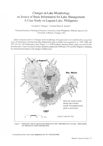
Changes in lake morphology as source of basic information for lake management: A case study on Laguna Lake, Philippines
(Southeast Asian Regional Center for Graduate Study and Research in Agriculture (SEARCA), 2005) -
Origin of Philippine lakes
(Southeast Asian Regional Center for Graduate Study and Research in Agriculture (SEARCA), 2005)The paper discusses the origin of the major and minor lakes throughout the Philippines.