02 SEAFDEC/AQD Collaborative Publications: Recent submissions
Now showing items 136-140 of 453
-
Series: Summary of Proceedings No. 1/2013;
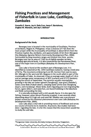
Fishing practices and management of fisherfolk in Looc Lake, Castillejos, Zambales
(PCAARRD-DOST, 2013)Barangay Looc is located in the municipality of Castillejos, Province of Zambales, Region III, Philippines. It has a distance of 7 km from the town proper while the municipality of Castillejos is about 60 km from the Province Capital, Iba, Zambales, and approximately 19 km from Olongapo City (Balaybay Agrarian Reform Community Development Plan, 2004). Surrounded by long mountain ranges and divided into three puroks, Barangay Looc has an area of 7,562 ha of slightly wooden terrains, including agricultural lands. It is also traversed by the Pamatawan River, one of the major rivers in Castillejos (Balaybay Arc Development Plan, 2004). Looc Lake is found at the southern part of Barangay Looc. It is identified as Cadastral Lot No. 1443 Castillejos Cadastre, having a total area of 52 ha. The mountains embracing it are Mt. Carmen from east to west, Mt. Sillangin in the west and Mt. Nagsasa in the south which is part of the municipality of Subic. As observed, it has an average water depth of 1.8 m and an average water temperature of 30°C (surface) and 27.5°C (bottom) during the month of September. The common aquatic macrophytes growing in the lake are water spinach ('kangkong'), tape grass ('balaiba'), water snow flake ('tukod-tukod'), creeping water prime rose ('kangkong dapa'), and ('tarabang'). Water birds, both migrating and non-migrating like heron, egret, bittern, and waterhen, are found frolicking in the lakeshore and fields surrounding the lake. It is naturally endowed with a rich aquatic fauna. It is also open for fishing. However, when Mount Pinatubo erupted, it was severely silted, depositing about 0.5 high ash and sand fall. Siltation was a permanent impact caused by this historical phenomenon over Looc Lake (Balaybay Arc Development Plan, 2004). Looc Lake plays a vital role in providing means of livelihood and serves as a source of income to its residents. At present, few studies had been done regarding the lake. It is for this reason that the researchers would like to study the said lake. -
Series: Summary of Proceedings No. 1/2013;
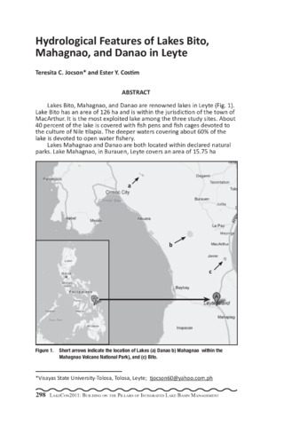
Hydrological features of Lakes Bito, Mahagnao, and Danao in Leyte
(PCAARRD-DOST, 2013)Lakes Bito, Mahagnao, and Danao are renowned lakes in Leyte (Fig. 1). Lake Bito has an area of 126 ha and is within the jurisdiction of the town of MacArthur. It is the most exploited lake among the three study sites. About 40 percent of the lake is covered with fish pens and fish cages devoted to the culture of Nile tilapia. The deeper waters covering about 60% of the lake is devoted to open water fishery. Lakes Mahagnao and Danao are both located within declared natural parks. Lake Mahagnao, in Burauen, Leyte covers an area of 15.75 ha (Francisco, et al., 2001). The whole lake area is devoted to open water fishery, aside from being a source of the micro-hydroelectric power that provides electricity to Barangays Lugsungan, Cansiboy, and Mahagnao. Lake Danao in Ormoc City covers an area of 148 ha. The lake supplies water to the cities of Ormoc and Tacloban. The lake is also developed for tourism, with activities like boating, swimming, and hook and line fishing. There is very limited information about these lakes, with prior studies conducted by Montemayor (1985) and Francisco, et al. (2001). The data obtained was part of a preliminary study on the biodiversity of aquatic flora and fauna of these three lakes. The study was conducted in a period of one year to come up with baseline information about the three lakes. Sampling was conducted once a month in each of the three lakes. Depth, percent transparency, pH level, temperature, and dissolved oxygen (DO) were monitored through a longitudinal survey. Depth was measured using a depth gauge, transparency was monitored using a secchi disc; and pH level was determined using a pen-type pH meter (Milwaukee). Temperature and dissolved oxygen were determined using a DO meter (Cyberscan DO 110). Univariate Analysis of Variance and Tukey HSD were the statistical tools used to analyze the data obtained. Results showed that overall mean depth of water ranged between 1.48 m and 1.90 m; 2.61 m and 4.92; and 2.84 m and 4.11 m in Lakes Bito, Mahagnao, and Danao, respectively (Table 1). Overall mean percent transparency were between 52.59% and 68.06 %; 40.35% and 92.37%; and 63.19% and 97.41 % in Lakes Bito, Mahagnao, and Danao, respectively. Overall mean temperature ranged from 24.99°C to 29.74°C; 20.74°C to 27.32°C; and 19.90°C to 25.60°C in Lakes Bito, Mahagnao, and Danao, respectively. Overall mean DO were between 4.04 mg/l and 10.77 mg/l; 5.37 mg/l and 13.28 mg/l; and 4.93 mg/l and 12.84 mg/l in Lakes Bito, Mahagnao, and Danao, respectively. Overall mean pH were between 6.3 and 8.3; 6.2 and 8.4; and 6.0 and 8.8 in Lakes Bito, Mahagnao, and Danao, respectively (Table 1). There were significant differences (P<0.01) in depth, transparency, temperature, and DO among the three lakes during the study period. No significant differences in pH were observed among the three lakes, although monthly fluctuations within each lake was observed. -
Series: Summary of Proceedings No. 1/2013;
Phylogeography of the freshwater sardine (Sardinella tawilis) in Taal Lake, Batangas and its implications for a sustainable management strategy
(PCAARRD-DOST, 2013)Sardinella tawilis (Clupeiformes: Clupeidae) is the world s only freshwater sardine and is endemic to Taal Lake, Batangas, Philippines. Locally referred to as tawilis, it is the most dominant and commercially important fishery of the lake, but in recent years severe depletion has been apparent in catch records. A proposed management strategy favors the demarcation of a new fish sanctuary; however, it is unclear which area in the lake is appropriate for conservation. This study applied molecular genetics tools to describe the phylogeographic pattern of tawilis across Taal Lake to determine whether a single or multiple stocks exist; and which location supports the highest level of haplotype diversity to assist in the placement of the fish sanctuary. One hundred and forty-one specimens were collected from eight fishing locations around Taal Lake. Fish were indentified, the DNA extracted using a Chelex-resin method, amplified for the ribosomal 16S and mtDNA Cyt B gene regions, and sequenced. Sequences were cleaned using the genetics software Sequencher v4.8 (GeneCode Corp.), aligned and phylogenetic trees visualized in MEGA v5 (Tamura et al., 2007), and assessed for haplotype composition by location using DnaSP v5.1 (Librado and Rozas, 2009). Results for the haplotype frequency analysis showed two dominant haplotypes to be common at most or all fishing locations, with northern basin locations of the lake supporting a higher mean and absolute number of haplotypes than locations in the southern basin. Yet no fishing ground contained more than 45% of the total observed haplotype diversity and thus no ideal location for a new fish reserve could be identified. Rather, all specimens formed a single clade with no significant divergence between individuals from the eight fishing grounds for both genetic markers (Fig. 1). This suggests that all tawilis within Taal Lake are part of a single, panmictic stock. Given the mixing population, we suggest that a closed season be considered as an alternative strategy in managing the world s only freshwater sardine fishery. -
Series: Summary of Proceedings No. 1/2013;
Seven lakes research program updates
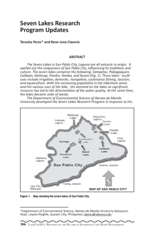
(PCAARRD-DOST, 2013)The Seven Lakes in San Pablo City, Laguna are all volcanic in origin. It spelled out the uniqueness of San Pablo City, influencing its traditions and culture. The seven lakes comprise the following: Sampaloc, Palaqpaquen, Calibato, Mohicap, Pandin, Yambo, and Bunot (Fig. 1). These lakes multiuses include irrigation, domestic, navigation, sustenance fishing, tourism, and aquaculture. With the increasing population in the lakeshore areas and the various uses of the lake, the demand on the lakes as significant resource has led to the deterioration of the water quality. At the same time, the lakes became sinks of waste. The Department of Environmental Science of Ateneo de Manila University developed the Seven Lakes Research Program in response to the urgent need to maintain the sustainability of the lakes uses. It has been coordinating with the local government units and the fisherfolk community and the FARMC for the past five years. The following are the expected outputs of the Department of Environmental Science for the Seven Lakes: 1. Determining Macrophyte Primary Production and Nutrient Availability in Lake Palacpaquen, San Pablo City, Laguna 2. An assessment of the Coliform Contamination in Sampaloc, Calibato and Mohicap Lake Waters and Selected Springs 3. A Comparative Study of the Effectiveness of Commercial and Farmmade feeds on the Growth of Tilapia 4. Nutrient Dispersion Patterns in Drainage and Lake Sediments: A Study of Sourcing for Selected Lakes in San Pablo City, Laguna 5. The Physico-Chemical Characterization of Sediments in Palacpaquen Lake and Adjoining River Systems, San Pablo City, Laguna 6. Assessing the Effects of Anthropogenic Activities to the Hydrology of San Pablo City, Laguna 7. A Geo-physical and Geo-chemical Assessment of Soils Surrounding Selected Lakes in San Pablo City, Laguna 8. Isolation and Characterization of Denitrifying and Phenoldegrading Microorganisms from Sampaloc Morphometry and Sedimentation of Palacpaquen Lake, San Pablo City, Laguna 9. An Assessment of the Phytoplankton and Macrobenthic Organisms as Biological Indicators in Calibato, Mohicap and Sampaloc Lakes 10. An Assessment of the Benthic Community Structure: Implications on the Water Quality of Lake Palacpaquen, San Pablo City, Philippines 11. A Study of the History of Fishery Utilization of Tilapia in Lake Palacpaquen, San Pablo City, Philippines There is also an existing collaboration with the Department of Electrical and Computer Engineering (ECE) of Ateneo de Manila University where using solar powered water pH, temperature and dissolved oxygen meters immersed in the Lake Palacpaquen are monitored and transmitted to the main server. The Department of Environmental Science is in the process of identifying gaps on the researches done in the Seven Lakes and assessing the future directions. -
Series: Summary of Proceedings No. 1/2013;
Land use and water quality assessment of some lakes in San Pablo City, Laguna, Philippines
(PCAARRD-DOST, 2013)Land conversions brought about by increasing population and the apparent increase of agricultural, residential, and commercial activities in San Pablo City have affected the quality of the water resources in the area. Agriculture and built-up areas comprised the majority of land use. Their assessment generated new interpretative maps after integrating remotely sensed data such as Landsat image and aerial photographs to various land use studies and surveys. The degradation of surface water quality was manifested by the physico-chemical analyses of sediments deposited in selected rivers and lakes. Sediments are considered as important source of information regarding water quality and chemical composition of water bodies. Sediments from Palacpaquen Lake and its adjoining rivers were assessed. The sulfate values of samples taken from different sites range from 47.79 ppm to 292.29 ppm, phosphates from 0.79 ppm to 5.53 ppm, nitrates from 146.98 ppm to 370.50 ppm, and organic carbon from 0.98 ppm to 4.56 ppm. The observed variability of nutrient concentrations were attributed mainly to anthropogenic activities around the lake and rivers which include agriculture, domestic and aquaculture. Land use has also affected groundwater resources, being one of the principal sources of drinking water. Untreated spring and well water are vulnerable to industrial, domestic, and agricultural pollution. Spring and well water from selected lakes such as Sampaloc, Mohicap, and Palacpaquen were monitored for total and fecal coliform contamination levels. There were varied levels of contamination. In most cases, the microbiological water quality in the sampled sites did not pass the drinking water standards of the Department of Health and the Department of Environment and Natural Resources. Proper land and water resource planning and management should be implemented to address the water quality degradation in San Pablo City.