タイトル のブラウズ: LakeCon2011
1-20 / 30
-
Series: Summary of Proceedings No. 1/2013;
Abundance and distribution of the green alga Botryococcus braunii Kützing (1849) in Paoay Lake, Ilocos Norte
(PCAARRD-DOST, 2013)Botryococcus braunii, a green colonial freshwater microalga that is currently found in Paoay Lake, Ilocos Norte, is recognized as a renewable source of energy. The monthly abundance and distribution of B. braunii in the lake in relation to the different physico-chemical parameters and other phytoplankton species were done from April 2009 to March 2010. Throughout the period of study, analysis of samples showed that B. braunii populations were present in all samples collected in the four sampling sites. Changes in cell density were noticeable, especially during the months of April and August. The highest recorded mean density was in August (2515 cells /mL) while the lowest mean density was in May (83 cells/mL). There were 38 genera of phytoplankton that co-existed with B. braunii in the lake. Physico-chemical parameters and nutrients were still within the range for growth of the alga. Fluctuations of these nutrients may be caused by seasonal variation and the occurrence of typhoons in the region. Growth of B. braunii population is positively correlated with temperature, conductivity and phytoplankton count while it is negatively correlated with DO, pH, transparency depth, NO3-, and PO43. Although B. braunii populations were present within the water column throughout the sampling period, the present environmental conditions did not allow the formation of blooms of this algal species. -
Series: Summary of Proceedings No. 1/2013
The Agusan Marsh and the Agusan River Basin: The need for science-based development and management
Primavera, Jurgenne (PCAARRD-DOST, 2013)
-
Series: Summary of Proceedings No. 1/2013;
Carbon credits for lake basin management
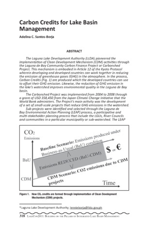
(PCAARRD-DOST, 2013)The Laguna Lake Development Authority (LLDA) pioneered the implementation of Clean Development Mechanism (CDM) activities through the Laguna de Bay Community Carbon Finance Project or Carbonshed Project. This mechanism is embodied in Article 12 of the Kyoto Protocol wherein developing and developed countries can work together in reducing the emission of greenhouse gases (GHG) in the atmosphere. In the process, Carbon Credits (Fig. 1) are produced which the developed countries can use to offset their GHG emission. Likewise, the reduction of GHG emission in the lake s watershed improves environmental quality in the Laguna de Bay basin. The Carbonshed Project was implemented from 2004 to 2008 through a grant of USD 358,450 from the Japan Climate Change Initiative that the World Bank administers. The Project s main activity was the development of a set of small-scale projects that reduce GHG emissions in the watershed. Sub-projects were identified and selected through the Laguna de Bay Environmental Action Planning (LEAP) process, a participative and multi-stakeholder planning process that include the LGUs, River Councils and communities in a particular municipality or sub-watershed. The LEAP process was developed under another World Bank and Dutch Governmentfunded project, the Laguna de Bay Institutional Strengthening and Community Participation Project or LISCOP that was implemented almost as the same time as the Carbonshed Project. The small-scale CDM sub-projects (Fig. 2) are being implemented by local government units (LGUs) with technical support from the LLDA and funding support under the LISCOP project. The first bundle under the Methane Avoidance Category consists of seven LGU sub-projects on Materials Recovery Facility with Composting. A significant milestone, both for the LLDA and for the participating LGUs was reached on March 16, 2008 with the registration of the Laguna de Bay Community Waste Management Project: Avoidance of Methane Production from Biomass Decay through Composting-1 to the United Nations Framework Convention on Climate Change- Clean Development Mechanism Executive Board (UNFCCC-CDMEB). The estimated Carbon Emission Reduction was 6,058 tons CO2-e. The buyers of Carbon Emission Reduction (CER), which translates into Carbon Credits is the Community Development Carbon Fund (CDCF). An Emission Reduction Purchase Agreement (ERPA) was signed on June 30, 2006 between the LLDA, representing the CDM-project participants and the World Bank, representing the CDCF. A sub-ERPA was then signed between the LLDA and the project participants as a commitment to meet the obligations under the ERPA. The Carbonshed Project has also established a mechanism to ensure that the money from the carbon credits will be used for operational costs of the existing composting facilities or for new environmental and social investments in the localities implementing these projects. -
Series: Summary of Proceedings No. 1/2013;
Dead zones in Philippine protected areas law: Institutional tolerance of lawbreaking and the complicity of the stakeholders
(PCAARRD-DOST, 2013)As many problems associated with the conservation and protection of lakes are perceived to be caused by the simple failure to enforce laws, this paper is an analysis of the myriad reasons behind the lack of law enforcement. These include high enforcement and transaction costs, overly broad scope of policies, conflicting laws or varying interpretations of laws, and lack of information or understanding of existing laws, among other reasons. It suggests that at least for some laws, these are not the main reasons for lack of implementation. Instead, both political leaders and stakeholders are complicit in such failure to enforce and therefore make what Tim Wu of the University of Columbia calls dead zones. The complicity can be due to economic and social benefits that lack of enforcement allows, the sources of which are perceived not to be morally reprehensible. Furthermore, using the policy-making and decision-making experience in the Taal Volcano Protected Landscape (Fig. 1), such complicity has boundaries and enforcement is agreed upon and even pushed when the economic benefits arising from the political failure are threatened. In the space where there is complicity in the failure to enforce, or where the resulting policy is overly broad and allows for selective enforcement, such complicity also leads to politicized decision-making, itself variably tolerated by stakeholders or opposed based on the risk versus economic benefits balance. Finally, the study suggests that despite the dead zones, there is an inherent aversion to withdrawing these unenforced laws from the books. Utpal Bhattacharya and Hazem Daouk of Cornell University, in their study of insider trading, suggests that unenforced law may be more harmful than no law at all. As such, the study was in the context of law-breaking for economic benefit, it is contrasted with law-breaking in a protected area for economic gain. Bhattacharya and Daouk suggests that a less transparent, unequal marketplace tends to disadvantage outsiders, and disadvantaged outsiders demand a higher return on their investments. The paper explores whether those disadvantaged by politicized decision-making on the issuance of licenses for fishcages in Taal Lake will tend to circumvent other protected area policies in order to get a higher return on investment, thereby creating a larger dead zone in a different area of regulation. Hence, the enforcement cost would be higher in terms of monitoring compliance with aquaculture regulations that are harder to monitor such as stocking density standards and feeding regulations. -
Series: Summary of Proceedings No. 1/2013;
ECONSERVE: Using healthy environment training to leverage the human potential of rural out of school youth to mobilize the lakeshore community for Naujan Lake biodiversity conservation
(PCAARRD-DOST, 2013) -
Series: Summary of Proceedings No. 1/2013;
Epipelic diatoms of Lake Caliraya, Laguna, Philippines
(PCAARRD-DOST, 2013)A taxonomic survey of diatom flora was conducted through sediments (from 25 cm to 200 cm depth) along the shoreline of Lake Caliraya, a man-made lake in Laguna Province, Philippines. There were a total of 63 diatom taxa belonging to three classes and 28 genera. About 93% were pennate diatoms and the other 7% are centric diatoms. Cocconeis placentula, Sellphora pupula, and Gomphonema accuminatum var. turris were the more abundant and frequently occurring pennate diatom species in the study. More frequently occurring centric diatoms include Aulacoseira granulata and Cyclotella menehegniana. Rarely occurring diatoms in this lake were also noted, including Synedra incisa, Fragilaria crotonensis, Bacillaria paxillifer, Craticula perotettii, and Amphora ovalis. -
Series: Summary of Proceedings No. 1/2013;
Establishment of fish reserve area in Taal Lake, Philippines
(PCAARRD-DOST, 2013)In 2007, The Protected Area Management Board (PAMB) of the Department of Environment and Natural Resources (DENR) approved a Unified Rules and Regulations (URR) for fisheries in the Taal Volcano Protected Landscape (TVPL). One of the provisions in the URR was the establishment of a fish reserve area which was also adopted in the newly approved TVPL Management Plan in 2009. The reserve area was about 1,000 hectares in the southern lakeside of volcano island under the municipalities of Balete, Matas na Kahoy, Sta. Teresita, and Cuenca. The boundaries were established by the Provincial Government of Batangas using a Global Positioning Satellite (GPS) and exact coordinates were identified. This study was conducted to gather baseline information on the biological, physical and chemical characteristics of water and the presence of fish larvae and fish early life in five sampling stations in the reserve area. The study was conducted for 4 months in 2010 (March, May, August, and September). Survey on fish larvae, egg and plankton were conducted using vertical and horizontal plankton towing. Physico-chemical parameters of water such as temperature, water depth, transparency, dissolved oxygen, pH, nitrites, and alkalinity were measured using a thermometer, echo sounder, secchi disk, and Lamotte test kit for freshwater, respectively. Preliminary results showed that there were fish larvae present in all stations except in Station 3, while all stations have the presence of fish eggs. There were three families of fish larvae identified which include Atherinidae, Blennidae and Syngnathidae. A total of 16 species of phytoplankton and 14 species of zooplankton were identified in all stations. The water depth ranged from 3.2 m. to more than 75 m. Station 1 was the deepest while Station 5 was the shallowest where abundant macrophytes were also observed. Water transparency in all stations ranged from 2.1 to 2.7 m. The temperature ranged from 30.5 to 32°C. Dissolved oxygen ranged from 5 to 7.1 ppm while the pH ranged from 4.0 to 9.0. Nitrites ranged from 0 to 0.1 ppm while alkalinity ranged from 185 to 220 ppm. High temperature and low pH readings were observed in May before PHIVOLCS announced Alert Level 2 in June 2010. Fishing operations of gill net, beach seine, ring net, and spear gun were also observed in the area. -
Series: Summary of Proceedings No. 1/2013;
A fisheries in crisis: Threatened biodiversity and fish production of Lake Mainit, northeastern Mindanao
(PCAARRD-DOST, 2013)Lake Mainit in Northeastern Mindanao is an important shared resource of the Provinces of Agusan del Norte and Surigao del Norte. It is distinguished as the deepest (219.35 m) and the fourth largest (17,060 ha) lake in the Philippines with 28 river tributaries and only one outlet river that flows into Butuan Bay. The most recent assessment in 2007-2008 showed that at least 15 species of aquatic plants, 41 species of fish, five crustaceans, and 10 mollusks occur in Lake Mainit and its outlet Kalinawan River. Lake Mainit has a very diverse fish community classified into three different groups, namely, true freshwater fishes (lake and riverine), amphidromous fishes, and catadromous fishes. This highly productive and diverse wetland ecosystem supports a thriving freshwater fishery and the livelihood of more than 3,000 fishers using a highly diverse fishing gear technology. The municipality of Kitcharao, Agusan del Norte has the largest contribution to fisheries production (Fig. 1). Environmental and human factors have threatened the biodiversity and productivity of the Lake in recent decades. Certain species of fish are feared to have been extinct; at least 13 of 37 species reported by Pauly et al. (1990) were no longer encountered in the present study. More than 65% of the fish are migratory between the lake and Butuan Bay through the Kalinawan River. The population of the once abundant giant mottled eel (Anguilla marmorata) has drastically declined, resulting from massive fishing on adult eels during their seasonal spawning along Kalinawan River. The native white goby (Glossogobius giuris), locally known as pijanga, remains the most important fishery resource in Lake Mainit (Fig. 2), but the current fish catch is about 63% of the 1997-98 production as reported by Galicia and Lopez (2000). Many species are caught in progressively smaller sizes, resulting in lower economic value and hence, marginal fisher incomes. Pollution, unsustainable fishing practices, high fishing pressure, and lack of enforcement of fisheries policies have drastically reduced the annual fish catch from 15,108 t in 1980-81 to only about 831.50 t in 2007-08, which is only about 5.5% of the production level 26 years ago. Lake Mainit experiences the typical syndrome of a threatened fisheries resources: biodiversity loss, high fishing pressure, use of unsustainable fishing gears and methods, declining fish catch and catch-per-unit-effort, decreasing size of fish caught, and marginal or meager fisher incomes barely enough to provide for the basic daily needs like food, health, and children s education. The Lake Mainit Development Alliance (LMDA), an inter-LGU alliance among the eight municipalities around the lake, provides a ray of hope for this threatened resource. A fisheries management program is being integrated into the Lake Mainit Development Agenda to help restore Lake Mainit fisheries resources to sustainable levels. -
Series: Summary of Proceedings No. 1/2013;
Fishery resource assessment of Taal Lake, Batangas, Philippines
(PCAARRD-DOST, 2013)An assessment of fishery resources of Taal Lake was conducted from January to December of 2010. Fish landed catch survey was done in major landing sites of 11 coastal towns around the lake. Sampling was done 20 days a month during peak landing time at 2 days interval. A participatory approach was done by training and hiring fisherfolk leaders to be the data enumerators of their respective towns. A survey form was used to gather the number of fishermen, boats and gears, catch/species composition, volume of catch, gears used, and fishing effort. A total of 1,054 fisherfolk was recorded in Taal Lake. Inventory of the fishing gear listed a total of 2,084 units of 15 different types of fishing gears used in the lake. Gill net was the most dominant gear with 1,258 units or about 60% of the total gears operating in the lake. Three active gears were identified namely, beach seine, motorized push net, and ring net. The average catch per unit effort of gill net was 6.6kg/day while beach seine, motorized push net, and ring net were 26 kg/day, 544 kg/day and 30 kg/day, respectively. There were 1,484 units of boat operating in the lake, of which 1,110 were motorized, 168 non-motorized, and 206 bamboo raft. Previous data showed that total fish production from 1996 to 2000 has declined from 1,420 mt to 882 mt. The highest catch was 1,672 mt in 1998. In 2010, the total production was 273.62 mt, a reduction of 69.7% from the 1998 production. A total of 47 species were recorded comprising of 38 finfishes, four crustaceans, three mollusks, and two reptiles. Of the finfishes caught, four were endemic, 10 introduced and 24 migratory species. The major fishes caught in the lake were Sardinella tawilis, 39.2%, Chanos chanos (26.2%), Oreochromis niloticus (10.8%), Parachromis managuensis (4.8%), and Glossogobius guirus (3.2%). New record of introduced species include pangasius (Pangasianodon hypopthalmus), jaguar fish (Parachromis managuensis), bighead carp (Aristicthys nobilis), red pacu (Macropopum colossoma), janitor fish (Pterygoplichthys disjunctivus), and freshwater turtle (Pelodiscus sinensis). -
Series: Summary of Proceedings No. 1/2013;
Fishery resources assessment in Caluangan Lake, Calapan, Mindoro
(PCAARRD-DOST, 2013)Lake Caluangan is a saline type of lake ecosystem. It provides fishery resources, numerous goods and services for residents in the area. The study aimed to assess Lake Caluangan ecosystem in terms of fishery resources and physico-chemical parameters. Specifically, it aimed to identify taxonomically the present fish species; (b) determine the catch per unit effort expressed as biomass/hr; (c) assess the physico-chemical parameters of lakes and relate the occurrence of fishes and (d) determine the social issues and activities that possibly affect the lake ecosystem. Five and three sampling stations were established in littoral and limnetic zones, respectively. Physico-chemical parameters were measured with three replicates per station. Fish sampling was conducted using different fishing gears. Cast net was used in the littoral zone, whereas various fishing gears such as hook and line, gill nets and lift nets were used in the limnetic zone. Fish were identified using fish keys/guides and FISHBASE. Social issues and activities were determined through interviews and ocular observations. A total of 18 fish species were collected in both zones. Six fish species were caught in the littoral zone, comprised of Scorpaenidae and Tetraodontidae families, Photopectoralis sp., Scolopsis sp., Gerres sp., and Mugil cephalus. On the other hand, nine species were caught in lift nets. These species were Sertola sp., Caranx sp., Mugil cephalus, Stolephorus sp., Apogon sp., Photopectoralis sp., Upeneus sp., Gerres sp., and Siganus sp. Moreover, Dussumieria sp., Glossogobius sp., Sphyraena sp., Terapon jarbua, Monodactylus sp., and Chanos chanos, were caught using hook and line and gill nets. Siganus sp. had the highest CPUE with a value of 1,421. 21 g/hr. This species has the highest commercial value among the fish species caught in the limnetic zone, followed by Caranx sp. and Apogon sp., which were observed in both littoral and limnetic zones. Results showed that physico-chemical parameters were suitable for fishery production. The present water quality condition and presence of fishery resources were indications that the lake has a great potential to accommodate migratory species. The results can be a basis for any management interventions to the lake and for future references. -
Series: Summary of Proceedings No. 1/2013;
Fishing practices and management of fisherfolk in Looc Lake, Castillejos, Zambales
(PCAARRD-DOST, 2013)Barangay Looc is located in the municipality of Castillejos, Province of Zambales, Region III, Philippines. It has a distance of 7 km from the town proper while the municipality of Castillejos is about 60 km from the Province Capital, Iba, Zambales, and approximately 19 km from Olongapo City (Balaybay Agrarian Reform Community Development Plan, 2004). Surrounded by long mountain ranges and divided into three puroks, Barangay Looc has an area of 7,562 ha of slightly wooden terrains, including agricultural lands. It is also traversed by the Pamatawan River, one of the major rivers in Castillejos (Balaybay Arc Development Plan, 2004). Looc Lake is found at the southern part of Barangay Looc. It is identified as Cadastral Lot No. 1443 Castillejos Cadastre, having a total area of 52 ha. The mountains embracing it are Mt. Carmen from east to west, Mt. Sillangin in the west and Mt. Nagsasa in the south which is part of the municipality of Subic. As observed, it has an average water depth of 1.8 m and an average water temperature of 30°C (surface) and 27.5°C (bottom) during the month of September. The common aquatic macrophytes growing in the lake are water spinach ('kangkong'), tape grass ('balaiba'), water snow flake ('tukod-tukod'), creeping water prime rose ('kangkong dapa'), and ('tarabang'). Water birds, both migrating and non-migrating like heron, egret, bittern, and waterhen, are found frolicking in the lakeshore and fields surrounding the lake. It is naturally endowed with a rich aquatic fauna. It is also open for fishing. However, when Mount Pinatubo erupted, it was severely silted, depositing about 0.5 high ash and sand fall. Siltation was a permanent impact caused by this historical phenomenon over Looc Lake (Balaybay Arc Development Plan, 2004). Looc Lake plays a vital role in providing means of livelihood and serves as a source of income to its residents. At present, few studies had been done regarding the lake. It is for this reason that the researchers would like to study the said lake. -
Series: Summary of Proceedings No. 1/2013;
GIS-assisted trans-boundary risk mapping for water related food, health assessment and disaster risk reduction: Pilot, Sta. Rosa-Silang sub-watershed
(PCAARRD-DOST, 2013)The academic institutions from Japan, the Research Institute for Nature and Humanities (RIHN) and the Yokohama National University (YNU) provided a four-year (2010-2013) research fund and engaged the College of Agriculture-UPLB, the College of Medicine, University of the Philippines Manila (UPM), and LLDA, to conduct the first ever comprehensive integrated and multi-disciplinary researches on ecology-related food and human health risks for the establishment of science-based decision making and policies to protect the environment for sustainable urbanization and land use development in and around the Laguna Lake Region. The pilot study is a GIS-based risk mapping and assessment of the Sta. Rosa-Silang sub-watershed to provide basis for trans-boundary risk management of sub-watershed resources. This hopes to reduce the threats and impacts of climate change related flooding on urban investment, food security, health security, and, on the overall quality of life and environment in Sta. Rosa City, located downstream of the Sta. Rosa-Silang sub-watershed. The study likewise provided the graphic illustration of trans-boundary roles and ecological interconnectivity, as well as positive complementation between sustainable farming systems in the headwaters and modern urbanization in the lower portions managed by two politically separate LGUs belonging to different towns and provinces. The GIS-based risk based technical evaluation maps clearly identify the phenomenon called landscape inversion which manifested itself as alluvial fan formation with special recognizable footprints for high flood risk areas. Ultimately, the overlaying of GIS maps contributed to the (a) scientific explanation about the anomalies of river system, (b) possible maximum coverage of old Laguna Lake and location of its original boundaries, (c) areas whose groundwater are most likely vulnerable to groundwater contamination; and (d) explanation to massive flood and spatially redefine the old Laguna Lake water lines as the aftermath of super typhoon Ondoy. -
Series: Summary of Proceedings No. 1/2013;
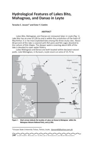
Hydrological features of Lakes Bito, Mahagnao, and Danao in Leyte
(PCAARRD-DOST, 2013)Lakes Bito, Mahagnao, and Danao are renowned lakes in Leyte (Fig. 1). Lake Bito has an area of 126 ha and is within the jurisdiction of the town of MacArthur. It is the most exploited lake among the three study sites. About 40 percent of the lake is covered with fish pens and fish cages devoted to the culture of Nile tilapia. The deeper waters covering about 60% of the lake is devoted to open water fishery. Lakes Mahagnao and Danao are both located within declared natural parks. Lake Mahagnao, in Burauen, Leyte covers an area of 15.75 ha (Francisco, et al., 2001). The whole lake area is devoted to open water fishery, aside from being a source of the micro-hydroelectric power that provides electricity to Barangays Lugsungan, Cansiboy, and Mahagnao. Lake Danao in Ormoc City covers an area of 148 ha. The lake supplies water to the cities of Ormoc and Tacloban. The lake is also developed for tourism, with activities like boating, swimming, and hook and line fishing. There is very limited information about these lakes, with prior studies conducted by Montemayor (1985) and Francisco, et al. (2001). The data obtained was part of a preliminary study on the biodiversity of aquatic flora and fauna of these three lakes. The study was conducted in a period of one year to come up with baseline information about the three lakes. Sampling was conducted once a month in each of the three lakes. Depth, percent transparency, pH level, temperature, and dissolved oxygen (DO) were monitored through a longitudinal survey. Depth was measured using a depth gauge, transparency was monitored using a secchi disc; and pH level was determined using a pen-type pH meter (Milwaukee). Temperature and dissolved oxygen were determined using a DO meter (Cyberscan DO 110). Univariate Analysis of Variance and Tukey HSD were the statistical tools used to analyze the data obtained. Results showed that overall mean depth of water ranged between 1.48 m and 1.90 m; 2.61 m and 4.92; and 2.84 m and 4.11 m in Lakes Bito, Mahagnao, and Danao, respectively (Table 1). Overall mean percent transparency were between 52.59% and 68.06 %; 40.35% and 92.37%; and 63.19% and 97.41 % in Lakes Bito, Mahagnao, and Danao, respectively. Overall mean temperature ranged from 24.99°C to 29.74°C; 20.74°C to 27.32°C; and 19.90°C to 25.60°C in Lakes Bito, Mahagnao, and Danao, respectively. Overall mean DO were between 4.04 mg/l and 10.77 mg/l; 5.37 mg/l and 13.28 mg/l; and 4.93 mg/l and 12.84 mg/l in Lakes Bito, Mahagnao, and Danao, respectively. Overall mean pH were between 6.3 and 8.3; 6.2 and 8.4; and 6.0 and 8.8 in Lakes Bito, Mahagnao, and Danao, respectively (Table 1). There were significant differences (P<0.01) in depth, transparency, temperature, and DO among the three lakes during the study period. No significant differences in pH were observed among the three lakes, although monthly fluctuations within each lake was observed. -
Series: Summary of Proceedings No. 1/2013;
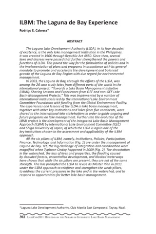
ILBM: The Laguna de Bay experience
(PCAARRD-DOST, 2013)The Laguna Lake Development Authority (LLDA), in its four decades of existence, is the only lake management institution in the Philippines. It was created in 1966 through Republic Act 4850. Since then, several laws and decrees were passed that further strengthened the powers and functions of LLDA. This paved the way for the formulation of policies and in the implementation of plans and programs in accordance with its general mandate to promote and accelerate the development and balanced growth of the Laguna de Bay Region with due regard for environmental management. In 2003, the Laguna de Bay, through the efforts of the LLDA, was among the 26 case study lakes from different parts of the world in the international project: Towards a Lake Basin Management Initiative (LBMI): Sharing Lessons and Experiences from GEF and non-GEF Lake Basin Management Projects. This was implemented by a number of international institutions led by the International Lake Environment Committee Foundation with funding from the Global Environment Facility. The experiences and lessons of the LLDA in lake basin management, together with other key institutions and lakes from five continents, were shared to the international lake stakeholders in order to guide ongoing and future programs on lake management. Further into the evolution of the LBMI project is the development of the Integrated Lake Basin Management Approach (ILBM) by International Lake Environment Committee (ILEC) and Shiga University of Japan, of which the LLDA is again one of the key institutions chosen in the assessment and applicability of the ILBM approach. All the six pillars of ILBM, namely, Institutions, Policies, Participation, Finance, Technology, and Information (Fig. 1) are under the management of Laguna de Bay. Yet, the big challenge of integration and coordination were magnified when Typhoon Ondoy happened in 2009 (Fig. 2). The devastation in the watershed, the loss of lives and properties, the flooding caused by denuded forests, uncontrolled development, and blocked waterways have shown that while the six pillars are present, they are not of the same strength. This has prompted the LLDA to revise its Master Plan in 2011 under the ILBM approach to reinforce and strengthen the weak pillars, to address the current pressures in the lake and in the watershed, and to respond to opportunities for better lake basin management. -
Series: Summary of Proceedings No. 1/2013;
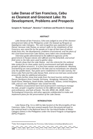
Lake Danao, San Francisco, Cebu as cleanest and greenest lake: Its development, problems and prospects
(PCAARRD-DOST, 2013)Lake Danao of San Francisco, Cebu was judged as one of the cleanest and greenest lakes of the Philippines under the Gawad ng Pangulo sa Kapaligiran Lake Category. The said recognition was awarded to Lake Danao because Lake Danao, as nature s gifts to the inhabitants of San Francisco, was cared for by the people as a sign of their love of nature. Aside from this, the development, problems encountered, and the plans of the Local Government for Lake Danao, were taken into consideration. Interview guide administered to the different agencies of the government in Pacijan Island, LGU officials and the fisherfolk, and actual field visits to the lake were used to gather data. Results show that the Lake Danao met the criteria for the national lake contest for its clean water and its environment and with abundant growth of plants around it. It is free from wastes and pollutants. Washing and bathing are now prohibited in the lake and no motorboats are allowed, only the paddle boats. Two parks were established in the lake namely, the Green Lake Park and the Lake Danao Park, and an eco trail was constructed around the lake for additional attraction. Results further show that aside from the local tourists visiting Lake Danao, foreigners from Canada, Germany, Hongkong, Indonesia, Italy, South Korea, Malaysia, Saudi Arabia, Switzerland, Taiwan, United Kingdom, USA, and our own 'balikbayan' also visited the lake. Problems encountered were lack of personnel s training to manage the lake, people s negative reactions to the different lake regulations and ordinances, and lack of funds. The LGU, BFAR, DA, DENR, Cebu Technological University, and other agencies collaborated to make and implement plans for the preservation of the Lake Danao. -
Series: Summary of Proceedings No. 1/2013;
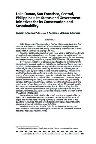
Lake Danao, San Francisco, central, Philippines: Its status and government initiatives for its conservation and sustainability
(PCAARRD-DOST, 2013)Lake Danao, a 649-hectare lake in Pacijan Island, was studied to find out its status in terms of activities of the inhabitants and government initiatives to conserve the lake, being the source of livelihood and a tourist destination in the Island Group of Camotes. Interview guide and actual field visits were used to gather data. Results show that fishing using gill nets and fish pots topped the activities of the inhabitants in Lake Danao, followed by 'suli-suli' gathering for mat weaving and other novelties, ecotourism, aquaculture, and nipa shingles making. Government initiatives in conserving and sustaining the lake include the legislative support declaring Lake Danao as flora and fauna sanctuary, requiring the barangay chairmen of six lakeshore barangays to implement activities for lake protection, declaring September 18 of every year as Municipal Clean Up Day in the marine and lake waters of San Francisco, prohibiting slash and burn farming on the lakeshore, prohibiting the cutting of mangroves and other tropical trees in the lake, banning birdhunting around the lake, suli-suli plant cutters/weavers to secure mayor s permit, prohibiting the use of motorized vessels in the lake, prohibiting carabao bathing and washing of clothes along the lakeshore, prohibiting construction of dwellings and other structures within 20 meters from the lakeshore, adopting and implementing Articles 51 and 52 of Republic Act 1067, prohibiting solid waste and garbage dumping in the lake, and collecting entrance fees from Lake Danao visitors and the creation of SAN FRANCISCO LAKEWATCH. Aquaculture activities in the lake is only granted to agencies like the BFAR, LGUs, and other agencies in order to control the proliferation of cages and maintain the carrying capacity of the lake. The BFAR-7 was quarterly restocking the lake with tilapia fingerlings and controlling the standard size of gill nets to be used in fishing. Academic institutions like the Cebu Technological University and BFAR-Region 7 conducted limnological researches on the lake to monitor the lake s health and sustainability. -
Series: Summary of Proceedings No. 1/2013;
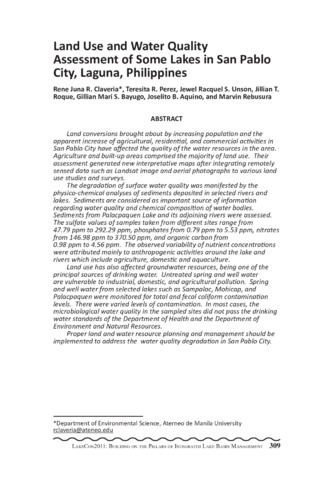
Land use and water quality assessment of some lakes in San Pablo City, Laguna, Philippines
(PCAARRD-DOST, 2013)Land conversions brought about by increasing population and the apparent increase of agricultural, residential, and commercial activities in San Pablo City have affected the quality of the water resources in the area. Agriculture and built-up areas comprised the majority of land use. Their assessment generated new interpretative maps after integrating remotely sensed data such as Landsat image and aerial photographs to various land use studies and surveys. The degradation of surface water quality was manifested by the physico-chemical analyses of sediments deposited in selected rivers and lakes. Sediments are considered as important source of information regarding water quality and chemical composition of water bodies. Sediments from Palacpaquen Lake and its adjoining rivers were assessed. The sulfate values of samples taken from different sites range from 47.79 ppm to 292.29 ppm, phosphates from 0.79 ppm to 5.53 ppm, nitrates from 146.98 ppm to 370.50 ppm, and organic carbon from 0.98 ppm to 4.56 ppm. The observed variability of nutrient concentrations were attributed mainly to anthropogenic activities around the lake and rivers which include agriculture, domestic and aquaculture. Land use has also affected groundwater resources, being one of the principal sources of drinking water. Untreated spring and well water are vulnerable to industrial, domestic, and agricultural pollution. Spring and well water from selected lakes such as Sampaloc, Mohicap, and Palacpaquen were monitored for total and fecal coliform contamination levels. There were varied levels of contamination. In most cases, the microbiological water quality in the sampled sites did not pass the drinking water standards of the Department of Health and the Department of Environment and Natural Resources. Proper land and water resource planning and management should be implemented to address the water quality degradation in San Pablo City. -
Series: Summary of Proceedings No. 1/2013;
Macrophytes of Lake Buluan
(PCAARRD-DOST, 2013)An investigation on the dominance and percent cover of macrophytes and invasive plant species in Lake Buluan, Sultan Kudarat was undertaken. Six sampling stations were surveyed, namely, LAT2, MAR1, SP7, SP8, CEN5, and CEN6. Coordinates of the different species were recorded and analyzed using ARC GIS to determine the percent cover of plants. Nelumbo sp., a native plant of Lake Buluan, occupies 39.21% of the area studied (Fig. 1). This is followed by Brachiaria and Eichhornia with 23.95% and 20.44%, respectively. Other species have the following percent cover: Phragmites, 8.68%, Ipomea, 3.84%, Scirpus, 3.55%, and Nymphea, 0.34%. On the other hand, two Sesbania sesban plants and an estimate of ten Polygonim barbatum plants were also identified. On the other hand, Eichhornia crassipes has a percent cover of 20.44% and is known to be an invasive plant commonly found in freshwater ecosystems. Along with invasive macrophytes are fauna species that may be associated with the different plant species identified, hence, a study about this is recommended. Because only the Sultan Kudarat area of the lake was surveyed, the Maguindanao area must be studied as well. -
Series: Summary of Proceedings No. 1/2013;
Morphological characterization using sensory canal pores and pit organs in goby fishes (Gobiidae) in Lake Mainit, Agusan del Norte
(PCAARRD-DOST, 2013)The taxonomic status of goby fishes in Lake Mainit, Agusan del Norte has not yet been properly established. Through morphological characterization, it could aid in identifying the fishes up to the species level. In this study, the arrangement of the sensory canal pores and pit organs on the cephalic region of the fish was used to determine its identity. Through this, it was known that all samples belong to Glossogobius giuris. Color patterns present after 95% ethanol immersion were also observed to evaluate which characteristics belong to this species even after decoloration. Procrustes Analysis was also employed to correlate the fish samples gathered in April 2006 and June 2007 in the study of Cherry Sara (2009) with the May 2009 samples obtained in this study by using the fishes morphometrics. This yielded a result that the fishes are correlated to one another with a correlation in a symmetric procrustes rotation value of 0.957 and Pvalue of 0.001. Therefore, fish samples collected from both studies are of the same species with respect to the similar season within a year. -
Series: Summary of Proceedings No. 1/2013;
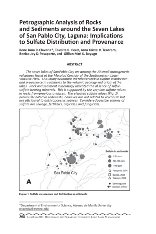
Petrographic analysis of rocks and sediments around the seven lakes of San Pablo City, Laguna: Implications to sulfate distribution and provenance
(PCAARRD-DOST, 2013)The seven lakes of San Pablo City are among the 20 small monogenetic volcanoes found at the Macolod Corridor of the Southwestern Luzon Volcanic Field. This study evaluated the relationship of sulfate distribution and provenance in sediments to the volcanic geology and origin of the lakes. Rock and sediment mineralogy indicated the absence of sulfursulfate bearing minerals. This is supported by the very low sulfate values in rocks from previous analyses. The elevated sulfate values (Fig. 1) previously noted in sediments, however, are not related to volcanism but are attributed to anthropogenic sources. Considered possible sources of sulfate are sewage, fertilizers, algicides, and fungicides.