การท่องเว็บ LakeCon2011 ตามวันที่ออก
Now showing items 1-20 of 30
-
Series: Summary of Proceedings No. 1/2013
The Agusan Marsh and the Agusan River Basin: The need for science-based development and management
Primavera, Jurgenne (PCAARRD-DOST, 2013)
-
Series: Summary of Proceedings No. 1/2013;
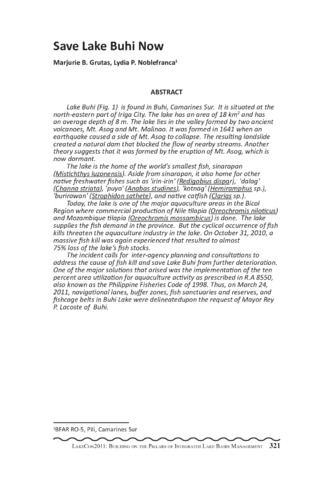
Save Lake Buhi now
(PCAARRD-DOST, 2013)Lake Buhi (Fig. 1) is found in Buhi, Camarines Sur. It is situated at the north-eastern part of Iriga City. The lake has an area of 18 km2 and has an average depth of 8 m. The lake lies in the valley formed by two ancient volcanoes, Mt. Asog and Mt. Malinao. It was formed in 1641 when an earthquake caused a side of Mt. Asog to collapse. The resulting landslide created a natural dam that blocked the flow of nearby streams. Another theory suggests that it was formed by the eruption of Mt. Asog, which is now dormant. The lake is the home of the world s smallest fish, sinarapan (Mistichthys luzonensis). Aside from sinarapan, it also home for other native freshwater fishes such as 'irin-irin' (Redigobius dispar), 'dalag' (Channa striata), 'puyo' (Anabas studines), 'kotnag' (Hemiramphus sp.), 'burirawan' (Strophidon sathete), and native catfish (Clarias sp.). Today, the lake is one of the major aquaculture areas in the Bicol Region where commercial production of Nile tilapia (Oreochromis niloticus) and Mozambique tilapia (Oreochromis mossambicus) is done. The lake supplies the fish demand in the province. But the cyclical occurrence of fish kills threaten the aquaculture industry in the lake. On October 31, 2010, a massive fish kill was again experienced that resulted to almost 75% loss of the lake s fish stocks. The incident calls for inter-agency planning and consultations to address the cause of fish kill and save Lake Buhi from further deterioration. One of the major solutions that arised was the implementation of the ten percent area utilization for aquaculture activity as prescribed in R.A 8550, also known as the Philippine Fisheries Code of 1998. Thus, on March 24, 2011, navigational lanes, buffer zones, fish sanctuaries and reserves, and fishcage belts in Buhi Lake were delineatedupon the request of Mayor Rey P. Lacoste of Buhi. -
Series: Summary of Proceedings No. 1/2013;
Seasonality, abundance and biology of tawilis (Sardinella tawilis) in Taal Lake, Batangas
(PCAARRD-DOST, 2013)A landed fish catch survey was conducted in ten landing centers around Taal Lake from June 2008 to May 2009. Fish catch and unit effort were recorded at 2 days interval for 10 days a month in the established sampling stations. Inventory of fisherfolk, boats, and gear was also conducted. A total of 300 'tawilis' samples per month were measured and dissected to determine the biological and population parameters. Results showed that there were 2,488 fisherfolk, 2,250 fishing boats, and 15,947 units of fishing gear recorded in Taal Lake. Tawilis production in the lake has declined. In 2009, tawilis production was 132 mt, a reduction of 82 % from the average production from 1996 to 2000. However, tawilis remained to be the most dominant fish in the open waters with about 36% of the total fish catch. The major gear used to catch tawilis were gill net and beach seine with catch per unit effort (CPUE) of 6 kg/day and 35 kg/day, respectively. There were 4,646 fish samples analyzed with an average fork length of 9.8 cm, average total length of 11.1 cm and an average weight of 13.2 g. The sex ratio obtained was 1 male to 0.85 female. Spawning of tawilis is all year round with highest gravid samples from March to May and November to December. Tawilis with an average fork length (FL) of 9.9 cm and weighs about 13.9 g has an estimated 4,848 eggs. The analysis of length frequency data has an estimated L8 of 16.8; K value of 0.59; total mortality (Z), 3.46; fishing mortality (F), 1.93; natural mortality (M), 1.54; and exploitation rate (E), 0.56. The fishing mortality was higher than the natural mortality and the exploitation rate exceeded the optimum 0.3-0.5 which implies that there is overfishing of tawilis in the lake. -
Series: Summary of Proceedings No. 1/2013;
Water quality trends of the Rinconada lake system and the implications in lake management
(PCAARRD-DOST, 2013)Monitoring of important water quality parameters were conducted in the Rinconada Lake System in Camarines Sur composed of Lake Bato (3,800 ha), Lake Buhi (1,800 ha), and Lake Baao-Bula (400 ha). Monthly samplings were conducted in 14 stations in Lakes Bato and Buhi and in ten stations in Lake Baao-Bula. For Lake Bato, dissolved oxygen at the surface is within the optimum range of 6.3 mg/L-10.47 mg/L for the wet seasons and 5.7 mg/L - 9 mg/L for the dry seasons but drops drastically at the bottom during the dry season. Critically low mean average of 0.71 mg/L prevailed in the diurnal oxygen trend. High levels of ammonia were recorded in particularly in Station 1 (0.81 mg/l), Station 2 (0.8125 mg/l), and Station 10 (0.8825 mg/l). The mean values of the water quality parameters of Lake Buhi from the surface to a depth of 4 m are within the optimum level. However, critically low dissolved oxygen and high levels of ammonia were recorded at the bottom, indicating the build up of anoxic layer. The Lake is stratified in most months of the year with a gradient difference of 1.74°C during the wet season and 2.15°C in the dry season. Dissolved oxygen, temperature and pH of Lake Baao-Bula is generally within the optimum levels with slight fluctuation in alkalinity. Nitrite (0.7 mg/l) and ammonia (1.5 mg/l) were critically high during the wet season. Results of the water quality monitoring provided management recommendations in establishing aquaculture zones, redesigning of cages and the use of the lakes for aquaculture and fisheries. -
Series: Summary of Proceedings No. 1/2013;
Macrophytes of Lake Buluan
(PCAARRD-DOST, 2013)An investigation on the dominance and percent cover of macrophytes and invasive plant species in Lake Buluan, Sultan Kudarat was undertaken. Six sampling stations were surveyed, namely, LAT2, MAR1, SP7, SP8, CEN5, and CEN6. Coordinates of the different species were recorded and analyzed using ARC GIS to determine the percent cover of plants. Nelumbo sp., a native plant of Lake Buluan, occupies 39.21% of the area studied (Fig. 1). This is followed by Brachiaria and Eichhornia with 23.95% and 20.44%, respectively. Other species have the following percent cover: Phragmites, 8.68%, Ipomea, 3.84%, Scirpus, 3.55%, and Nymphea, 0.34%. On the other hand, two Sesbania sesban plants and an estimate of ten Polygonim barbatum plants were also identified. On the other hand, Eichhornia crassipes has a percent cover of 20.44% and is known to be an invasive plant commonly found in freshwater ecosystems. Along with invasive macrophytes are fauna species that may be associated with the different plant species identified, hence, a study about this is recommended. Because only the Sultan Kudarat area of the lake was surveyed, the Maguindanao area must be studied as well. -
Series: Summary of Proceedings No. 1/2013;
The recreational value of Taal Volcano protected landscape: An exploratory benefit transfer application
(PCAARRD-DOST, 2013)Some landscapes that have significant value to people are protected through statute. Protected landscapes that serve as popular recreational resources and destinations hold significant use values for the people that visit them. Recognition of these recreational benefits of protected landscapes provides a sound economic rationale for their management. This paper provides estimates of the potential magnitude of recreational value via benefit transfers of Taal Volcano Protected Landscape in the Philippines - a major tourist attraction and designated as one of the key priority biodiversity areas for protection. Taal Volcano Protected Landscape is a popular area for recreation activities such as hiking, day-camping, picnicking, bird watching, horseback riding, fishing, boating, wind surfing, sailing, rowing, and kayaking. Benefit transfer is the use of information from research conducted on other sites (i.e., the study sites) to pose questions at a site (i.e., Taal Volcano Protected Landscape, the policy site) that lacks primary research. Benefit transfer approaches include: 1) transferring of values or functions from a single site or set of similar sites, and 2) estimating a meta-regression transfer function that can be used to predict values for the policy site in question. One study site in the Philippines was selected and used in a point estimate transfer application. Likewise, a meta-regression transfer function model was estimated based on selected study sites from the US. These study sites were selected based on their similarity in terms of recreation activity, climate, and/or site characteristics with that of the Taal Volcano Protected Landscape. Furthermore, implicit price deflators and purchasing power parity are incorporated to account for income and cost of living differences between the study and policy sites. Exogenous factors, such as differences in individual preferences, cultural, and institutional conditions between the Philippines and the United States are beyond the scope of this paper, but these have the potential to invalidate the result of an international benefit transfer. Results show that point estimate transfer approach provided a better estimate of access value than meta-regression benefit function transfer approach. While in-sample benefit transfer predictions of the metaregression model show an absolute percentage transfer error of 18%, the simple out-of-sample prediction result has very high absolute percentage transfer error (1,231%). Hence, in policy application, a model with more than 100% transfer error is not suggested. The estimated welfare estimate of recreational access using point estimate transfer was P36/person per trip in 2006. The aggregated recreational benefits at the Taal Volcano Protected Landscape in 2006 was P9.7 million from 155,701 visitors at the Batangas side and P118.9 million from 1,906,242 visitors at the Cavite side, for a sum of about P128 million. This access value is not equivalent to economic resources that can be generated when visitor use fees is imposed to the users. User fees should be based on a willingness-to-pay (WTP) study that captures public perceptions and WTP fees, among others. -
Series: Summary of Proceedings No. 1/2013;
Morphological characterization using sensory canal pores and pit organs in goby fishes (Gobiidae) in Lake Mainit, Agusan del Norte
(PCAARRD-DOST, 2013)The taxonomic status of goby fishes in Lake Mainit, Agusan del Norte has not yet been properly established. Through morphological characterization, it could aid in identifying the fishes up to the species level. In this study, the arrangement of the sensory canal pores and pit organs on the cephalic region of the fish was used to determine its identity. Through this, it was known that all samples belong to Glossogobius giuris. Color patterns present after 95% ethanol immersion were also observed to evaluate which characteristics belong to this species even after decoloration. Procrustes Analysis was also employed to correlate the fish samples gathered in April 2006 and June 2007 in the study of Cherry Sara (2009) with the May 2009 samples obtained in this study by using the fishes morphometrics. This yielded a result that the fishes are correlated to one another with a correlation in a symmetric procrustes rotation value of 0.957 and Pvalue of 0.001. Therefore, fish samples collected from both studies are of the same species with respect to the similar season within a year. -
Series: Summary of Proceedings No. 1/2013;
Fishery resource assessment of Taal Lake, Batangas, Philippines
(PCAARRD-DOST, 2013)An assessment of fishery resources of Taal Lake was conducted from January to December of 2010. Fish landed catch survey was done in major landing sites of 11 coastal towns around the lake. Sampling was done 20 days a month during peak landing time at 2 days interval. A participatory approach was done by training and hiring fisherfolk leaders to be the data enumerators of their respective towns. A survey form was used to gather the number of fishermen, boats and gears, catch/species composition, volume of catch, gears used, and fishing effort. A total of 1,054 fisherfolk was recorded in Taal Lake. Inventory of the fishing gear listed a total of 2,084 units of 15 different types of fishing gears used in the lake. Gill net was the most dominant gear with 1,258 units or about 60% of the total gears operating in the lake. Three active gears were identified namely, beach seine, motorized push net, and ring net. The average catch per unit effort of gill net was 6.6kg/day while beach seine, motorized push net, and ring net were 26 kg/day, 544 kg/day and 30 kg/day, respectively. There were 1,484 units of boat operating in the lake, of which 1,110 were motorized, 168 non-motorized, and 206 bamboo raft. Previous data showed that total fish production from 1996 to 2000 has declined from 1,420 mt to 882 mt. The highest catch was 1,672 mt in 1998. In 2010, the total production was 273.62 mt, a reduction of 69.7% from the 1998 production. A total of 47 species were recorded comprising of 38 finfishes, four crustaceans, three mollusks, and two reptiles. Of the finfishes caught, four were endemic, 10 introduced and 24 migratory species. The major fishes caught in the lake were Sardinella tawilis, 39.2%, Chanos chanos (26.2%), Oreochromis niloticus (10.8%), Parachromis managuensis (4.8%), and Glossogobius guirus (3.2%). New record of introduced species include pangasius (Pangasianodon hypopthalmus), jaguar fish (Parachromis managuensis), bighead carp (Aristicthys nobilis), red pacu (Macropopum colossoma), janitor fish (Pterygoplichthys disjunctivus), and freshwater turtle (Pelodiscus sinensis). -
Series: Summary of Proceedings No. 1/2013;
Preliminary observations on the diel vertical migration of crustacean zooplankton in aquaculture and aquaculture-free areas of Lake Taal, Philippines
(PCAARRD-DOST, 2013)Freshwater zooplankton in tropical caldera lakes with intensive aquaculture are exposed to physical, chemical, and biological influences that have differences with other lake types. This study compares the diel vertical migration of crustacean zooplankton between aquaculture and aquaculture-free areas in a tropical caldera lake (Lake Taal, Philippines). Environmental conditions showed little variation in both basins, and crustacean zooplankton showed similar DVM patterns. Wind-induced water movements, volcanic inputs and zooplankton exposure to similar levels of predation influenced zooplankton DVM in the lake. The zooplankton DVM patterns confirm that there is homogeneity in zooplankton composition and distribution in aquaculture and aquaculture-free areas. -
Series: Summary of Proceedings No. 1/2013;
Lake Danao, San Francisco, central, Philippines: Its status and government initiatives for its conservation and sustainability
(PCAARRD-DOST, 2013)Lake Danao, a 649-hectare lake in Pacijan Island, was studied to find out its status in terms of activities of the inhabitants and government initiatives to conserve the lake, being the source of livelihood and a tourist destination in the Island Group of Camotes. Interview guide and actual field visits were used to gather data. Results show that fishing using gill nets and fish pots topped the activities of the inhabitants in Lake Danao, followed by 'suli-suli' gathering for mat weaving and other novelties, ecotourism, aquaculture, and nipa shingles making. Government initiatives in conserving and sustaining the lake include the legislative support declaring Lake Danao as flora and fauna sanctuary, requiring the barangay chairmen of six lakeshore barangays to implement activities for lake protection, declaring September 18 of every year as Municipal Clean Up Day in the marine and lake waters of San Francisco, prohibiting slash and burn farming on the lakeshore, prohibiting the cutting of mangroves and other tropical trees in the lake, banning birdhunting around the lake, suli-suli plant cutters/weavers to secure mayor s permit, prohibiting the use of motorized vessels in the lake, prohibiting carabao bathing and washing of clothes along the lakeshore, prohibiting construction of dwellings and other structures within 20 meters from the lakeshore, adopting and implementing Articles 51 and 52 of Republic Act 1067, prohibiting solid waste and garbage dumping in the lake, and collecting entrance fees from Lake Danao visitors and the creation of SAN FRANCISCO LAKEWATCH. Aquaculture activities in the lake is only granted to agencies like the BFAR, LGUs, and other agencies in order to control the proliferation of cages and maintain the carrying capacity of the lake. The BFAR-7 was quarterly restocking the lake with tilapia fingerlings and controlling the standard size of gill nets to be used in fishing. Academic institutions like the Cebu Technological University and BFAR-Region 7 conducted limnological researches on the lake to monitor the lake s health and sustainability. -
Series: Summary of Proceedings No. 1/2013;
Abundance and distribution of the green alga Botryococcus braunii Kützing (1849) in Paoay Lake, Ilocos Norte
(PCAARRD-DOST, 2013)Botryococcus braunii, a green colonial freshwater microalga that is currently found in Paoay Lake, Ilocos Norte, is recognized as a renewable source of energy. The monthly abundance and distribution of B. braunii in the lake in relation to the different physico-chemical parameters and other phytoplankton species were done from April 2009 to March 2010. Throughout the period of study, analysis of samples showed that B. braunii populations were present in all samples collected in the four sampling sites. Changes in cell density were noticeable, especially during the months of April and August. The highest recorded mean density was in August (2515 cells /mL) while the lowest mean density was in May (83 cells/mL). There were 38 genera of phytoplankton that co-existed with B. braunii in the lake. Physico-chemical parameters and nutrients were still within the range for growth of the alga. Fluctuations of these nutrients may be caused by seasonal variation and the occurrence of typhoons in the region. Growth of B. braunii population is positively correlated with temperature, conductivity and phytoplankton count while it is negatively correlated with DO, pH, transparency depth, NO3-, and PO43. Although B. braunii populations were present within the water column throughout the sampling period, the present environmental conditions did not allow the formation of blooms of this algal species. -
Series: Summary of Proceedings No. 1/2013;
Lake Danao, San Francisco, Cebu as cleanest and greenest lake: Its development, problems and prospects
(PCAARRD-DOST, 2013)Lake Danao of San Francisco, Cebu was judged as one of the cleanest and greenest lakes of the Philippines under the Gawad ng Pangulo sa Kapaligiran Lake Category. The said recognition was awarded to Lake Danao because Lake Danao, as nature s gifts to the inhabitants of San Francisco, was cared for by the people as a sign of their love of nature. Aside from this, the development, problems encountered, and the plans of the Local Government for Lake Danao, were taken into consideration. Interview guide administered to the different agencies of the government in Pacijan Island, LGU officials and the fisherfolk, and actual field visits to the lake were used to gather data. Results show that the Lake Danao met the criteria for the national lake contest for its clean water and its environment and with abundant growth of plants around it. It is free from wastes and pollutants. Washing and bathing are now prohibited in the lake and no motorboats are allowed, only the paddle boats. Two parks were established in the lake namely, the Green Lake Park and the Lake Danao Park, and an eco trail was constructed around the lake for additional attraction. Results further show that aside from the local tourists visiting Lake Danao, foreigners from Canada, Germany, Hongkong, Indonesia, Italy, South Korea, Malaysia, Saudi Arabia, Switzerland, Taiwan, United Kingdom, USA, and our own 'balikbayan' also visited the lake. Problems encountered were lack of personnel s training to manage the lake, people s negative reactions to the different lake regulations and ordinances, and lack of funds. The LGU, BFAR, DA, DENR, Cebu Technological University, and other agencies collaborated to make and implement plans for the preservation of the Lake Danao. -
Series: Summary of Proceedings No. 1/2013;
ECONSERVE: Using healthy environment training to leverage the human potential of rural out of school youth to mobilize the lakeshore community for Naujan Lake biodiversity conservation
(PCAARRD-DOST, 2013) -
Series: Summary of Proceedings No. 1/2013;
Fishery resources assessment in Caluangan Lake, Calapan, Mindoro
(PCAARRD-DOST, 2013)Lake Caluangan is a saline type of lake ecosystem. It provides fishery resources, numerous goods and services for residents in the area. The study aimed to assess Lake Caluangan ecosystem in terms of fishery resources and physico-chemical parameters. Specifically, it aimed to identify taxonomically the present fish species; (b) determine the catch per unit effort expressed as biomass/hr; (c) assess the physico-chemical parameters of lakes and relate the occurrence of fishes and (d) determine the social issues and activities that possibly affect the lake ecosystem. Five and three sampling stations were established in littoral and limnetic zones, respectively. Physico-chemical parameters were measured with three replicates per station. Fish sampling was conducted using different fishing gears. Cast net was used in the littoral zone, whereas various fishing gears such as hook and line, gill nets and lift nets were used in the limnetic zone. Fish were identified using fish keys/guides and FISHBASE. Social issues and activities were determined through interviews and ocular observations. A total of 18 fish species were collected in both zones. Six fish species were caught in the littoral zone, comprised of Scorpaenidae and Tetraodontidae families, Photopectoralis sp., Scolopsis sp., Gerres sp., and Mugil cephalus. On the other hand, nine species were caught in lift nets. These species were Sertola sp., Caranx sp., Mugil cephalus, Stolephorus sp., Apogon sp., Photopectoralis sp., Upeneus sp., Gerres sp., and Siganus sp. Moreover, Dussumieria sp., Glossogobius sp., Sphyraena sp., Terapon jarbua, Monodactylus sp., and Chanos chanos, were caught using hook and line and gill nets. Siganus sp. had the highest CPUE with a value of 1,421. 21 g/hr. This species has the highest commercial value among the fish species caught in the limnetic zone, followed by Caranx sp. and Apogon sp., which were observed in both littoral and limnetic zones. Results showed that physico-chemical parameters were suitable for fishery production. The present water quality condition and presence of fishery resources were indications that the lake has a great potential to accommodate migratory species. The results can be a basis for any management interventions to the lake and for future references. -
Series: Summary of Proceedings No. 1/2013;
Establishment of fish reserve area in Taal Lake, Philippines
(PCAARRD-DOST, 2013)In 2007, The Protected Area Management Board (PAMB) of the Department of Environment and Natural Resources (DENR) approved a Unified Rules and Regulations (URR) for fisheries in the Taal Volcano Protected Landscape (TVPL). One of the provisions in the URR was the establishment of a fish reserve area which was also adopted in the newly approved TVPL Management Plan in 2009. The reserve area was about 1,000 hectares in the southern lakeside of volcano island under the municipalities of Balete, Matas na Kahoy, Sta. Teresita, and Cuenca. The boundaries were established by the Provincial Government of Batangas using a Global Positioning Satellite (GPS) and exact coordinates were identified. This study was conducted to gather baseline information on the biological, physical and chemical characteristics of water and the presence of fish larvae and fish early life in five sampling stations in the reserve area. The study was conducted for 4 months in 2010 (March, May, August, and September). Survey on fish larvae, egg and plankton were conducted using vertical and horizontal plankton towing. Physico-chemical parameters of water such as temperature, water depth, transparency, dissolved oxygen, pH, nitrites, and alkalinity were measured using a thermometer, echo sounder, secchi disk, and Lamotte test kit for freshwater, respectively. Preliminary results showed that there were fish larvae present in all stations except in Station 3, while all stations have the presence of fish eggs. There were three families of fish larvae identified which include Atherinidae, Blennidae and Syngnathidae. A total of 16 species of phytoplankton and 14 species of zooplankton were identified in all stations. The water depth ranged from 3.2 m. to more than 75 m. Station 1 was the deepest while Station 5 was the shallowest where abundant macrophytes were also observed. Water transparency in all stations ranged from 2.1 to 2.7 m. The temperature ranged from 30.5 to 32°C. Dissolved oxygen ranged from 5 to 7.1 ppm while the pH ranged from 4.0 to 9.0. Nitrites ranged from 0 to 0.1 ppm while alkalinity ranged from 185 to 220 ppm. High temperature and low pH readings were observed in May before PHIVOLCS announced Alert Level 2 in June 2010. Fishing operations of gill net, beach seine, ring net, and spear gun were also observed in the area. -
Series: Summary of Proceedings No. 1/2013;
Fishing practices and management of fisherfolk in Looc Lake, Castillejos, Zambales
(PCAARRD-DOST, 2013)Barangay Looc is located in the municipality of Castillejos, Province of Zambales, Region III, Philippines. It has a distance of 7 km from the town proper while the municipality of Castillejos is about 60 km from the Province Capital, Iba, Zambales, and approximately 19 km from Olongapo City (Balaybay Agrarian Reform Community Development Plan, 2004). Surrounded by long mountain ranges and divided into three puroks, Barangay Looc has an area of 7,562 ha of slightly wooden terrains, including agricultural lands. It is also traversed by the Pamatawan River, one of the major rivers in Castillejos (Balaybay Arc Development Plan, 2004). Looc Lake is found at the southern part of Barangay Looc. It is identified as Cadastral Lot No. 1443 Castillejos Cadastre, having a total area of 52 ha. The mountains embracing it are Mt. Carmen from east to west, Mt. Sillangin in the west and Mt. Nagsasa in the south which is part of the municipality of Subic. As observed, it has an average water depth of 1.8 m and an average water temperature of 30°C (surface) and 27.5°C (bottom) during the month of September. The common aquatic macrophytes growing in the lake are water spinach ('kangkong'), tape grass ('balaiba'), water snow flake ('tukod-tukod'), creeping water prime rose ('kangkong dapa'), and ('tarabang'). Water birds, both migrating and non-migrating like heron, egret, bittern, and waterhen, are found frolicking in the lakeshore and fields surrounding the lake. It is naturally endowed with a rich aquatic fauna. It is also open for fishing. However, when Mount Pinatubo erupted, it was severely silted, depositing about 0.5 high ash and sand fall. Siltation was a permanent impact caused by this historical phenomenon over Looc Lake (Balaybay Arc Development Plan, 2004). Looc Lake plays a vital role in providing means of livelihood and serves as a source of income to its residents. At present, few studies had been done regarding the lake. It is for this reason that the researchers would like to study the said lake. -
Series: Summary of Proceedings No. 1/2013;
Hydrological features of Lakes Bito, Mahagnao, and Danao in Leyte
(PCAARRD-DOST, 2013)Lakes Bito, Mahagnao, and Danao are renowned lakes in Leyte (Fig. 1). Lake Bito has an area of 126 ha and is within the jurisdiction of the town of MacArthur. It is the most exploited lake among the three study sites. About 40 percent of the lake is covered with fish pens and fish cages devoted to the culture of Nile tilapia. The deeper waters covering about 60% of the lake is devoted to open water fishery. Lakes Mahagnao and Danao are both located within declared natural parks. Lake Mahagnao, in Burauen, Leyte covers an area of 15.75 ha (Francisco, et al., 2001). The whole lake area is devoted to open water fishery, aside from being a source of the micro-hydroelectric power that provides electricity to Barangays Lugsungan, Cansiboy, and Mahagnao. Lake Danao in Ormoc City covers an area of 148 ha. The lake supplies water to the cities of Ormoc and Tacloban. The lake is also developed for tourism, with activities like boating, swimming, and hook and line fishing. There is very limited information about these lakes, with prior studies conducted by Montemayor (1985) and Francisco, et al. (2001). The data obtained was part of a preliminary study on the biodiversity of aquatic flora and fauna of these three lakes. The study was conducted in a period of one year to come up with baseline information about the three lakes. Sampling was conducted once a month in each of the three lakes. Depth, percent transparency, pH level, temperature, and dissolved oxygen (DO) were monitored through a longitudinal survey. Depth was measured using a depth gauge, transparency was monitored using a secchi disc; and pH level was determined using a pen-type pH meter (Milwaukee). Temperature and dissolved oxygen were determined using a DO meter (Cyberscan DO 110). Univariate Analysis of Variance and Tukey HSD were the statistical tools used to analyze the data obtained. Results showed that overall mean depth of water ranged between 1.48 m and 1.90 m; 2.61 m and 4.92; and 2.84 m and 4.11 m in Lakes Bito, Mahagnao, and Danao, respectively (Table 1). Overall mean percent transparency were between 52.59% and 68.06 %; 40.35% and 92.37%; and 63.19% and 97.41 % in Lakes Bito, Mahagnao, and Danao, respectively. Overall mean temperature ranged from 24.99°C to 29.74°C; 20.74°C to 27.32°C; and 19.90°C to 25.60°C in Lakes Bito, Mahagnao, and Danao, respectively. Overall mean DO were between 4.04 mg/l and 10.77 mg/l; 5.37 mg/l and 13.28 mg/l; and 4.93 mg/l and 12.84 mg/l in Lakes Bito, Mahagnao, and Danao, respectively. Overall mean pH were between 6.3 and 8.3; 6.2 and 8.4; and 6.0 and 8.8 in Lakes Bito, Mahagnao, and Danao, respectively (Table 1). There were significant differences (P<0.01) in depth, transparency, temperature, and DO among the three lakes during the study period. No significant differences in pH were observed among the three lakes, although monthly fluctuations within each lake was observed. -
Series: Summary of Proceedings No. 1/2013;
Phylogeography of the freshwater sardine (Sardinella tawilis) in Taal Lake, Batangas and its implications for a sustainable management strategy
(PCAARRD-DOST, 2013)Sardinella tawilis (Clupeiformes: Clupeidae) is the world s only freshwater sardine and is endemic to Taal Lake, Batangas, Philippines. Locally referred to as tawilis, it is the most dominant and commercially important fishery of the lake, but in recent years severe depletion has been apparent in catch records. A proposed management strategy favors the demarcation of a new fish sanctuary; however, it is unclear which area in the lake is appropriate for conservation. This study applied molecular genetics tools to describe the phylogeographic pattern of tawilis across Taal Lake to determine whether a single or multiple stocks exist; and which location supports the highest level of haplotype diversity to assist in the placement of the fish sanctuary. One hundred and forty-one specimens were collected from eight fishing locations around Taal Lake. Fish were indentified, the DNA extracted using a Chelex-resin method, amplified for the ribosomal 16S and mtDNA Cyt B gene regions, and sequenced. Sequences were cleaned using the genetics software Sequencher v4.8 (GeneCode Corp.), aligned and phylogenetic trees visualized in MEGA v5 (Tamura et al., 2007), and assessed for haplotype composition by location using DnaSP v5.1 (Librado and Rozas, 2009). Results for the haplotype frequency analysis showed two dominant haplotypes to be common at most or all fishing locations, with northern basin locations of the lake supporting a higher mean and absolute number of haplotypes than locations in the southern basin. Yet no fishing ground contained more than 45% of the total observed haplotype diversity and thus no ideal location for a new fish reserve could be identified. Rather, all specimens formed a single clade with no significant divergence between individuals from the eight fishing grounds for both genetic markers (Fig. 1). This suggests that all tawilis within Taal Lake are part of a single, panmictic stock. Given the mixing population, we suggest that a closed season be considered as an alternative strategy in managing the world s only freshwater sardine fishery. -
Series: Summary of Proceedings No. 1/2013;
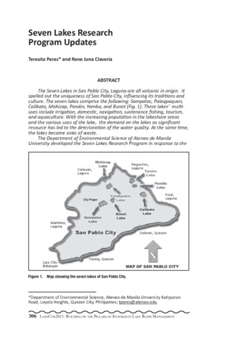
Seven lakes research program updates
(PCAARRD-DOST, 2013)The Seven Lakes in San Pablo City, Laguna are all volcanic in origin. It spelled out the uniqueness of San Pablo City, influencing its traditions and culture. The seven lakes comprise the following: Sampaloc, Palaqpaquen, Calibato, Mohicap, Pandin, Yambo, and Bunot (Fig. 1). These lakes multiuses include irrigation, domestic, navigation, sustenance fishing, tourism, and aquaculture. With the increasing population in the lakeshore areas and the various uses of the lake, the demand on the lakes as significant resource has led to the deterioration of the water quality. At the same time, the lakes became sinks of waste. The Department of Environmental Science of Ateneo de Manila University developed the Seven Lakes Research Program in response to the urgent need to maintain the sustainability of the lakes uses. It has been coordinating with the local government units and the fisherfolk community and the FARMC for the past five years. The following are the expected outputs of the Department of Environmental Science for the Seven Lakes: 1. Determining Macrophyte Primary Production and Nutrient Availability in Lake Palacpaquen, San Pablo City, Laguna 2. An assessment of the Coliform Contamination in Sampaloc, Calibato and Mohicap Lake Waters and Selected Springs 3. A Comparative Study of the Effectiveness of Commercial and Farmmade feeds on the Growth of Tilapia 4. Nutrient Dispersion Patterns in Drainage and Lake Sediments: A Study of Sourcing for Selected Lakes in San Pablo City, Laguna 5. The Physico-Chemical Characterization of Sediments in Palacpaquen Lake and Adjoining River Systems, San Pablo City, Laguna 6. Assessing the Effects of Anthropogenic Activities to the Hydrology of San Pablo City, Laguna 7. A Geo-physical and Geo-chemical Assessment of Soils Surrounding Selected Lakes in San Pablo City, Laguna 8. Isolation and Characterization of Denitrifying and Phenoldegrading Microorganisms from Sampaloc Morphometry and Sedimentation of Palacpaquen Lake, San Pablo City, Laguna 9. An Assessment of the Phytoplankton and Macrobenthic Organisms as Biological Indicators in Calibato, Mohicap and Sampaloc Lakes 10. An Assessment of the Benthic Community Structure: Implications on the Water Quality of Lake Palacpaquen, San Pablo City, Philippines 11. A Study of the History of Fishery Utilization of Tilapia in Lake Palacpaquen, San Pablo City, Philippines There is also an existing collaboration with the Department of Electrical and Computer Engineering (ECE) of Ateneo de Manila University where using solar powered water pH, temperature and dissolved oxygen meters immersed in the Lake Palacpaquen are monitored and transmitted to the main server. The Department of Environmental Science is in the process of identifying gaps on the researches done in the Seven Lakes and assessing the future directions. -
Series: Summary of Proceedings No. 1/2013;
Land use and water quality assessment of some lakes in San Pablo City, Laguna, Philippines
(PCAARRD-DOST, 2013)Land conversions brought about by increasing population and the apparent increase of agricultural, residential, and commercial activities in San Pablo City have affected the quality of the water resources in the area. Agriculture and built-up areas comprised the majority of land use. Their assessment generated new interpretative maps after integrating remotely sensed data such as Landsat image and aerial photographs to various land use studies and surveys. The degradation of surface water quality was manifested by the physico-chemical analyses of sediments deposited in selected rivers and lakes. Sediments are considered as important source of information regarding water quality and chemical composition of water bodies. Sediments from Palacpaquen Lake and its adjoining rivers were assessed. The sulfate values of samples taken from different sites range from 47.79 ppm to 292.29 ppm, phosphates from 0.79 ppm to 5.53 ppm, nitrates from 146.98 ppm to 370.50 ppm, and organic carbon from 0.98 ppm to 4.56 ppm. The observed variability of nutrient concentrations were attributed mainly to anthropogenic activities around the lake and rivers which include agriculture, domestic and aquaculture. Land use has also affected groundwater resources, being one of the principal sources of drinking water. Untreated spring and well water are vulnerable to industrial, domestic, and agricultural pollution. Spring and well water from selected lakes such as Sampaloc, Mohicap, and Palacpaquen were monitored for total and fecal coliform contamination levels. There were varied levels of contamination. In most cases, the microbiological water quality in the sampled sites did not pass the drinking water standards of the Department of Health and the Department of Environment and Natural Resources. Proper land and water resource planning and management should be implemented to address the water quality degradation in San Pablo City.